3D Laser Scanning

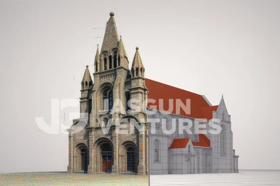
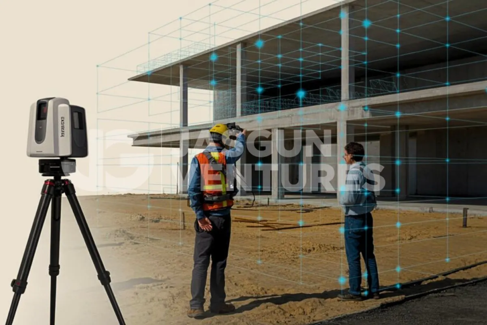
At Jasgun, we specialize in high-precision 3D laser scanning in India, helping clients document existing conditions with clarity and speed. Our LiDAR survey and reality capture services are engineered to support everything from architectural renovations to industrial retrofits. We provide millimeter-accurate data that drives confident design and construction. 

Jasgun Ventures offers end-to-end reality capture solutions tailored to the needs of architects, engineers, contractors, and facility managers. Our scanning workflows are optimized for minimal disruption and maximum detail. 

With a strong foundation in digital construction and field expertise, we reduce rework and accelerate project timelines. At Jasgun, laser scanning is the first step toward smarter and lifecycle-ready construction. 

3D Laser Scanning Services in india | Jasgun Ventures

We conduct high-definition LiDAR scans of built environments. From residential apartments to industrial campuses, our team delivers centimeter-accurate spatial data for:

  • Architectural renovations
  • Structural analysis
  • Facade mapping and deformation tracking

Even the most intricate features of heritage monuments and historic facades are captured in full 3D detail.

After scanning, we transform your point clouds into intelligent Revit-based BIM models, tailored to your required LOD (Level of Detail).

  • Clash-ready BIM for coordination
  • As-built validation before design
  • Compatible with architectural, structural & MEP disciplines

Ideal for design firms, contractors, and owners seeking digital project visualization and seamless collaboration.

We convert laser scan data into precise 2D CAD drawings—perfect for projects where BIM is not required but technical accuracy is critical.

  • Drafted floor plans, sections, and elevations based on verified site conditions
  • Ideal for renovation, documentation, compliance drawings, and layout planning
  • Compatible with AutoCAD (.DWG), MicroStation, and other native formats
  • Frequently used by architects, interior designers, and civil consultants for submission to local bodies like DDA, MMRDA, BBMP, and others

Our Scan-to-CAD service simplifies workflows for real estate upgrades, tenant fit-outs, and legacy building redevelopments across India’s urban and Tier-2 cities.

We produce accurate 2D and 3D as-built documentation derived from detailed point cloud data, ensuring that every element reflects existing site conditions with precision.

  • Floor plans, sections, and elevations based on verified geometry
  • Reflected ceiling plans for lighting, mechanical, and architectural coordination
  • MEP redlining and spatial layout drawings to support system upgrades and retrofits

All documentation is developed in compliance with project-specific standards and applicable codes.

We deliver high-accuracy topographic and site surveys using advanced 3D laser scanning technology. Our scans capture every contour enabling the creation of precise digital terrain models (DTMs) that support informed planning and design decisions.

  • Detailed land grading and cut-fill analysis
  • Seamless GIS integration for infrastructure and urban planning
  • Scanning support for roads, rail corridors, utility layouts, and landscape design

Compared to traditional total station methods, our LiDAR-based topographic surveys provide superior coverage, reducing field time and accelerating project delivery.

We provide high-precision 3D laser scanning services for operational industrial facilities. Our services captures complex environments with minimal disruption to daily operations. Our expertise spans across:

  • Oil refineries, manufacturing plants, data centers, and utility facilities
  • Comprehensive capture of pipework, structural steel, and mechanical equipment
  • Accurate layouts to support maintenance, shutdown planning, and retrofit design

Using advanced LiDAR technology and clash-free scan-to-BIM modeling, we help facility managers, EPC contractors, and design teams visualize existing conditions, reduce safety risks, and optimize project timelines for industrial upgrades.

  • Deep AEC Domain Expertise
    With a strong foundation in architecture, engineering, and BIM workflows, we understand the complexities of construction environments and project lifecycles.
  • Precision with Turnaround Efficiency
    Our laser scanning services are designed to meet demanding project schedules, delivering accurate, ready-to-use data without delays.
  • International-Grade Quality
    We follow globally recognized standards in scanning, modeling, and documentation, ensuring compatibility with international design and construction requirements.
  • Rapid On-Site Deployment
    Our agile team is equipped to mobilize quickly across diverse locations in India, including high-security, remote, and time-sensitive job sites.
3D Laser Scanning Services in india | Jasgun Ventures

Step 1: Understanding & 3D Scanning 
We begin with a detailed scope review, followed by on-site LiDAR scanning using industry-grade equipment to capture high-precision spatial data. 

Step 2: Point Cloud Processing & Drafting 
The raw scan data is cleaned, aligned, and processed into structured point clouds, ready for accurate CAD or BIM modeling as per project requirements. 

Step 3: Delivery & Review 
We provide fully documented outputs, including drawings, models, and accuracy reports, followed by a review session to ensure alignment with your goals. 

Commercial & Residential Real Estate

Heritage Conservation & Restoration

Healthcare & Hospital Campuses

Manufacturing & Industrial Facilities

Retail, Hospitality & Mall Fit-outs

Educational Institutions & Government Buildings

Case Study
Clash-free BIM for a commercial high-rise.
Project Snapshots
4D VDC scheduling for a large renovation.
Case study
Point cloud to BIM for a historical structure.
What is the accuracy level of your 3D laser scans?

Our LiDAR scanning systems deliver sub-centimeter accuracy, typically within ±2mm—ideal for high-precision architectural, structural, and MEP documentation.

Yes. We offer raw point cloud data (.RCP, .E57) as well as LOD-specific BIM models in Revit and AutoCAD formats. Deliverables are tailored to your project stage and platform preferences.

Turnaround time depends on project size and complexity. However, most standard scans and BIM models are delivered within 5–10 business days, with expedited options available.

Absolutely. Our team is equipped to mobilize quickly across tier-1 cities, tier-2 towns, industrial zones, and remote project sites across India.
Yes. We specialize in non-intrusive scanning for occupied spaces like hospitals, factories, and office buildings, with minimal disruption to ongoing operations.

Jasgun’s laser scanning saved us weeks in design time. The BIM model was spot-on, and we avoided three major site errors.

img

- Project Manager and Commercial Developer.

Testimonial “We used to revisit our sites multiple times, now we get everything captured in one go. Fast, precise, and reliable.

img

- Architect, Heritage Restoration Project.

Don’t wait for costly surprises onsite. Let Jasgun Ventures digitally document your space and streamline your next project.

Keep in touch

Let's Talk

Phone : +12 3 1462 2249, 2248
Fax : +12 9 1462 2238, 2248

E-mail Us